


Aqua Map Boating

Description of Aqua Map Boating
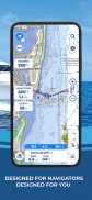
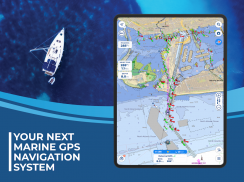
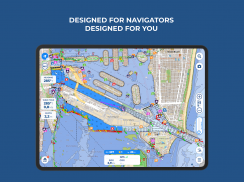
Aqua Map Boating is a navigation app designed for marine enthusiasts, offering users access to official nautical charts and various features to enhance their boating experience. The app is available for the Android platform and can be downloaded for easy access to its functionalities. Aqua Map Boating provides users with a comprehensive suite of tools for safe and efficient navigation on the water.
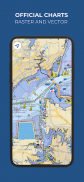
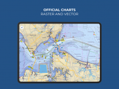
The app delivers weekly updates of official nautical charts from the National Oceanic and Atmospheric Administration (NOAA), ensuring that users have the most current information available for their marine journeys. By purchasing a chart subscription for specific areas of interest, users can download the maps for offline use, allowing for seamless navigation without relying on internet connectivity.
In addition to chart access, Aqua Map Boating includes several basic features that enhance the navigation experience. Users can overlay satellite images onto the charts, providing a more detailed view of their surroundings. The app allows for manual route creation and track recording, enabling users to plan their trips effectively and document their journeys. Navigation data, including markers, routes, and recorded tracks, can be stored and shared with others, fostering a sense of community among users.
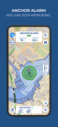
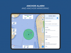
Tides and currents predictions are also integrated into the app, offering simulations that inform users about water conditions. This feature contributes to safer navigation by allowing users to anticipate changes in tides and currents. The Anchor Alarm feature adds an extra layer of safety, alerting users if their vessel drifts beyond a predetermined distance from a set anchor point.
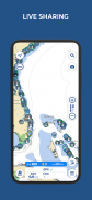
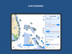
Live Sharing functionality enables real-time interaction with the Aqua Map community, facilitating communication and information exchange among users. This feature can be particularly beneficial for those boating in popular areas, as it allows for the sharing of local insights and experiences.
Aqua Map Boating also provides access to points of interest from the ActiveCaptain and Waterway Guide communities. This information can enhance the boating experience by highlighting local attractions, facilities, and important navigation details that may not be readily apparent on traditional charts.
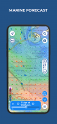
For users seeking advanced features, Aqua Map Boating offers an Expert subscription. This subscription must be paired with a chart subscription and includes marine forecasts that provide detailed information on wind, waves, currents, gusts, salinity, and sea surface temperatures for any point on the map. This data is essential for making informed decisions while on the water.
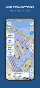
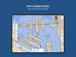
The Advanced AnchorLink feature included in the Expert subscription enhances security for those who anchor their vessels. It allows for anchorage mirroring and notifications via email or messaging apps, ensuring that users can stay informed about their vessel's position even while away from the boat. Additionally, users can connect their NMEA instruments through WiFi, integrating data from devices such as autopilots, depth sounders, wind sensors, compasses, and GPS into the app, which creates a more connected and informed navigation experience.
The app also includes an AIS (Automatic Identification System) feature with automatic collision detection, adding another layer of safety for users navigating busy waterways. This system helps boaters avoid potential collisions by alerting them to the presence of nearby vessels.
For those looking for the ultimate navigation experience, the Master subscription provides all the features of the Expert subscription, along with additional local data for U.S. users. This includes surveys from the U.S. Army Corps of Engineers, which are essential for safe navigation in shallow waters, and a list of U.S. Coast Guard lights and local notices to mariners, ensuring users remain informed about important navigational aids and updates.
To access the various features of Aqua Map Boating, users must purchase a chart subscription for their area of interest. The option to add the Expert or Master subscription allows users to unlock further navigation features and additional data to enhance their overall experience on the water. Subscription payments are made through the user's Google account, and annual subscriptions automatically renew unless canceled at least 24 hours before expiration. Users can manage their subscriptions and disable automatic renewal directly within the account settings.
Aqua Map Boating combines essential navigation tools with comprehensive charting capabilities, making it a valuable resource for both recreational and serious boaters. The app's focus on safety, community interaction, and advanced features allows users to navigate with confidence and enjoy their time on the water.
For further details, you can visit the terms of use at https://www.aquamap.app/terms-and-conditions and the privacy policy at https://www.aquamap.app/privacy-policy.
Aqua Map Boating - Version 33.2
(07-04-2025)
Aqua Map Boating - APK Information
APK Version: 33.2Package: com.gec.MarineApp.WorldViewerLiteLatest Version of Aqua Map Boating
Other versions


Apps in the same category


